


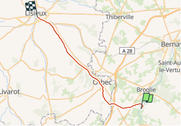
Basse Normandie - Ligne 401 - La-Trinité-de-Réville - Lisieux

mich54
User


5m
Difficulty : Unknown

FREE GPS app for hiking
 SityTrail
IGN / Geographical institutes
SityTrail Plus
The world is yours!
About
Trail Other activity of 32 km to be discovered at Normandy, Eure, La Trinité-de-Réville. This trail is proposed by mich54.
Description
La ligne de La Trinité-de-Réville à Lisieux est une ancienne ligne ferroviaire française déclassée. Il s'agissait à l'origine d'un embranchement qui suivait la vallée de l'Orbiquet entre la gare de Lisieux, sur la ligne de Mantes-la-Jolie à Cherbourg, et la ville d'Orbec, distante d'une quinzaine de kilomètres. La ligne fut ensuite prolongée jusqu'à La Trinité-de-Réville afin de rejoindre la ligne d'Échauffour à Bernay.(Source Wikipédia)
Beaucoup de difficulté pour retrouver les traces de ce parcours, incertain par endroit.


Positioning
Comments